Foreword
This report extends the earlier analysis of the sea surface temperature (SST) of the Calabrian Tyrrhenian coast, applying it in comparative mode to four coastal stretches that cover the entire perimeter of Calabria: the Tyrrhenian, the Far South (Scilla-Reggio Calabria-Bovalino, including the Strait of Messina), the South Ionian (Capo Spartivento-Crotone) and the North Ionian (Crotone-Roseto Capo Spulico). The starting question is a general-interest one, but it has concrete implications for the tourism and bathing sector:
Why does the Calabrian Ionian coast - historically perceived as 'less affected' than the Tyrrhenian by phenomena such as mucilage, brown foam and algal blooms - seem to cope better? Is it because the sea is actually cooler? Because there is more wind? Because there are other structural factors at play?
The analysis that follows is based on the same public Copernicus data already used in the main report (SST 1982-2025), enriched with:
- Extending the study domain from the Tyrrhenian alone to the whole Calabrian coast, defining four comparable geographical boxes (Tyrrhenian, Far South, South Ionian, North Ionian).
- The addition of a variable that is crucial for mucilage: the sea-surface wind (Copernicus Marine wind 2007-2025).
- An independent check of the wind data through the Global Wind Atlas (GWA), the world reference for wind climatology, produced by DTU Wind Energy and the World Bank.
Let us anticipate the conclusion straight away, because it refutes the most intuitive hypothesis: the Calabrian Ionian coast is not significantly cooler than the Tyrrhenian - on some metrics it is in fact warmer. The difference in mucilage is therefore only partly explained by wind (the South Ionian is indeed windier), and mainly by structural factors that satellites cannot measure directly: bathymetry, currents, and the configuration of the coast.
Supplementary glossary
Please refer to the main report for the full glossary of SST, MHW, EPS, TEP, CMEMS, etc. Only the specific terms introduced by the comparison between coasts are listed here.
| Term / Acronym | Meaning |
|---|---|
| GWA - Global Wind Atlas | A global climatic wind atlas, produced by DTU Wind Energy (Technical University of Denmark) in partnership with the World Bank. It freely distributes high-resolution maps (~250 m) of the annual mean wind speed at various heights (10, 50, 100, 150, 200 m), based on physical downscaling (WAsP/WRF) of the ERA5 reanalysis. Originally designed for the sizing of wind farms, it is excellent for validating coarser-grid data. |
| Wind U10 / V10 | The horizontal components of the wind measured 10 metres above the sea surface. U10 = the east-west component (positive eastward), V10 = the north-south component (positive northward). The magnitude is √(U10² + V10²) and represents the total speed. 10 m is the international marine-meteorological standard for surface winds. |
| Thermal stratification | A sea configuration in which a warm surface layer floats on a cold deep layer, without mixing. Typical of summer. Wind is the main factor that breaks it down: weak wind = stable stratification = conditions potentially favourable to mucilage. |
| Bathymetry | The depth of the seabed. Coasts with a wide continental shelf (e.g. the Gulf of Sant'Eufemia) have shallow seabeds for kilometres offshore; coasts with steep seabeds (much of the Calabrian Ionian) have depths >500 m just a few km from the shore. Bathymetry conditions dynamic mixing. |
| Ionian and Tyrrhenian currents | The Atlantic Ionian Stream (AIS) is a cyclonic current that enters from the Sicily Channel and runs along the northern edge of the Ionian Sea, generally dynamic. The Tyrrhenian, by contrast, features semi-stationary anticyclonic eddies in its gulfs, typically less mobile. |
| Calm window | A derived indicator: the number of consecutive periods (e.g. ≥10 days) in which the daily mean wind stays below a threshold (e.g. 5 m/s). More windows = more stratification conditions favourable to mucilage. |
| WRF / WAsP | Micro-scale atmospheric models used for the downscaling (spatial refinement) of wind from a coarse grid (~30 km of the ERA5 reanalysis) to a fine grid (~250 m). WRF = Weather Research and Forecasting; WAsP = Wind Atlas Analysis and Application Program, of DTU. |
| ASCAT / HSCAT | Microwave space-borne scatterometers on board the MetOp satellites (ESA/EUMETSAT) and HY-2 (China). They measure the roughness of the sea surface caused by the wind and infer its speed and direction. They are the main source of direct observation of marine wind. |
1. Methodological extension
1.1 The four coastal stretches
The analysis was replicated over four comparable geographical boxes that fully cover the Calabrian coast. The study was initially set up over three zones (Tyrrhenian, South Ionian, North Ionian), excluding the Strait of Messina because of its particular dynamics; in a second phase a fourth box (Far South) was added, covering exactly Scilla → Reggio Calabria → Bovalino, thus making it possible to assess the effect of the strong currents of the Strait on SST and wind as well. The table below lists all four:
| Coast | Latitude (°N) | Longitude (°E) | Geographical extremes | Extent | Notes |
|---|---|---|---|---|---|
| Tyrrhenian | 38.25 - 39.95 | 15.60 - 16.30 | Praia a Mare -> Scilla | ~189 x 60 km | Coast already analysed in the main report; includes the Gulf of Sant'Eufemia |
| Far South | 37.85 - 38.25 | 15.55 - 16.30 | Scilla -> Reggio C. -> Bovalino | ~44 x 65 km | Strait of Messina, Capo dell'Armi, Capo Spartivento. A zone of strong currents, intermediate bathymetry |
| South Ionian | 37.95 - 39.05 | 16.30 - 17.20 | Capo Spartivento -> Crotone | ~122 x 78 km | Locride, Costa dei Saraceni, Soverato, Catanzaro Marina |
| North Ionian | 39.05 - 39.95 | 16.55 - 17.20 | Crotone -> Roseto C.S. | ~100 x 50 km | Crotone area, Cirò Marina, Sibari plain |
1.2 Added variable: the marine wind
To test the role of wind in distinguishing the conditions favourable to mucilage formation, the following dataset was downloaded:
cmems_obs-wind_glo_phy_my_l4_0.125deg_PT1H
This is the Copernicus Marine 'Global Ocean Hourly Reprocessed Sea Surface Wind and Stress' product, with the following characteristics:
| Characteristic | Value |
|---|---|
| Geographical coverage | Global (here cropped to the 4 Calabrian boxes) |
| Period covered | 11 January 2007 - 31 December 2025 (19 years) |
| Spatial resolution | 0.125° (~13 km) |
| Temporal resolution | 1 value every hour (~166,000 points per box) |
| Variables used | eastward_wind (U10), northward_wind (V10) → magnitude √(U²+V²) |
| Processing | Aggregation to a daily mean to reduce the data volume |
| Source | A combination of scatterometer observations (ASCAT, HSCAT) + ECMWF reanalysis |
| Reference | Wind at 10 m above the sea surface (marine-meteorological standard) |
The wind covers only 19 years (2007-2025), against the 44 of the SST. This limits the long-term trend analyses of wind alone, but it is amply sufficient for the comparison between regions over the same recent period.
1.3 Independent check with the Global Wind Atlas
To be sure that the observed wind pattern is not an artefact of the Copernicus dataset, a check was carried out with another completely independent source: the Global Wind Atlas (GWA), produced by DTU Wind Energy in collaboration with the World Bank. The GWA provides high spatial-resolution climatologies (250 m) based on micro-scale downscaling (WAsP/WRF models) of the ERA5 reanalysis.
The GeoTIFF file for Italy at a height of 10 m (47 MB) was downloaded via the GWA API. For each of the 4 boxes the spatial mean of the pixels was computed and compared with the corresponding mean of the Copernicus data (same period, same 10 m reference height).
| Coast | GWA (climatology, 10 m, 250 m) | Copernicus annual mean | Copernicus summer mean (May-Sep) | Δ |GWA - Cop| |
|---|---|---|---|---|
| Tyrrhenian | 2.61 m/s | 2.83 m/s | 2.26 m/s | 0.22 m/s |
| South Ionian | 4.52 m/s | 4.19 m/s | 3.50 m/s | 0.33 m/s |
| North Ionian | 3.39 m/s | 3.30 m/s | 2.74 m/s | 0.09 m/s |
The values agree to within 0.2-0.3 m/s, a difference fully within the order of the uncertainty between different products at a 10 m height. The relative pattern (South Ionian > North Ionian ≈ Far South > Tyrrhenian) is confirmed. This means that the Copernicus figures we will use in the rest of the report are not an artefact: the wind regime of the four coasts is genuinely different and independently documented.
Note: the GWA also includes land pixels (the coast, and the mountains immediately behind it such as the Pollino, Sila and Aspromonte massifs) that contribute to raising the value relative to the open-sea-only Copernicus data. In addition, the GWA climatology covers the whole year (including the winter winds, on average stronger), whereas the Copernicus summer mean is limited to May-September. The residual differences between the two datasets are therefore explainable and not substantial.
2. The four coastal stretches: an overview
Figure 1 shows the four analysis zones overlaid on the map of the mean SST anomaly for 2015-2024 (relative to the 1991-2020 climatology). The representation is uniform: the same colour scale for all four coasts, the same comparison period.
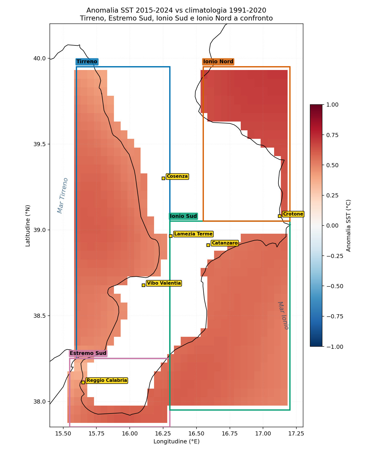
Figure 1 — Mean SST anomaly 2015-2024 vs the 1991-2020 climatology for the four Calabrian coasts: Tyrrhenian (blue box), Far South (pink-magenta, at the bottom), South Ionian (green), North Ionian (orange). Red indicates waters warmer than the historical average. The shades are visually very similar across the four stretches: the warming is regional, not local.
What can already be seen at a glance
- All four coasts have a positive anomaly (red) - no zone of Calabria is in thermal retreat.
- The colour intensity is uniform between the Tyrrhenian, the Far South, the South Ionian and the North Ionian. There are differences, but they are of the order of 0.2-0.3 °C, of the same order as the instrumental uncertainty.
- The North Ionian (Crotone area-Sibari plain) appears slightly darker: it indeed has the highest anomaly of the four.
- The Far South (Strait of Messina) appears slightly lighter, consistently with the cooler summer SST documented in the following chapters.
- The Gulf of Sant'Eufemia (central Tyrrhenian) and the Locri-Soverato stretch (South Ionian) are visually similar in intensity.
3. Temperature: the four seas warm in a similar way
The first finding the comparison returns is clear-cut: the four Calabrian seas undergo warming of practically identical intensity. The small differences (0.5-0.9 °C in absolute values) are incapable on their own of explaining significant ecological differences.
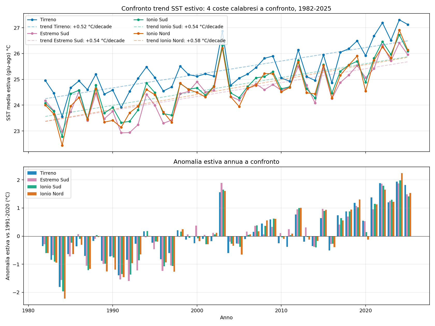
Figure 2 — Comparison of the summer SST trend for the four Calabrian coasts, 1982-2025. Upper panel: annual series of the mean summer SST (Jun-Aug) for each coast, with the respective regression line. Lower panel: annual summer anomaly of each coast relative to the 1991-2020 climatology. The four series are visibly aligned.
Key figures
| Indicator | Tyrrhenian | Far South | South Ionian | North Ionian |
|---|---|---|---|---|
| Mean summer SST trend (°C/decade) | +0.52 | +0.54 | +0.54 | +0.58 |
| Mean summer SST 2024 (°C) | 27.31 | 26.41 | 26.73 | 26.91 |
| Summer anomaly 2024 (°C) | +1.94 | +1.88 | +1.98 | +2.24 |
| Maximum daily anomaly of the series (°C) | +4.24 (2023) | +3.95 (2022) | +4.07 (2022) | +4.39 (2024) |
| Change in summer SST 1982 vs 2024 (°C) | +2.30 | +2.30 | +2.40 | +2.60 |
Four counter-intuitive observations:
- The North Ionian has the steepest trend (+0.58 °C/decade) and the highest 2024 anomaly (+2.24 °C), greater than the Tyrrhenian (+1.94 °C).
- The Far South (Strait of Messina and the immediately adjacent Ionian) is the coolest coast of all: a 2024 summer SST of 26.41 °C, an anomaly of +1.88 °C. The presence of the strong currents of the Strait produces a measurable dynamic cooling effect.
- In absolute terms the summer SST of the Tyrrhenian is the highest (27.31 °C), but the difference with the other coasts is only ~0.5-0.9 °C - in any case modest for biological purposes.
- The widespread idea that 'the Ionian is cooler, therefore it suffers less' is not supported by the data. The warming is uniform across the whole region; the differences in the coastal manifestations must be explained by other factors.
3.1 MHW: the Ionian too is hit by marine heatwaves
Marine Heat Waves are the main mechanism that translates warming into ecosystem stress (see the main report for the full definition). Figure 3 shows the annual frequency of MHW for the four coasts.
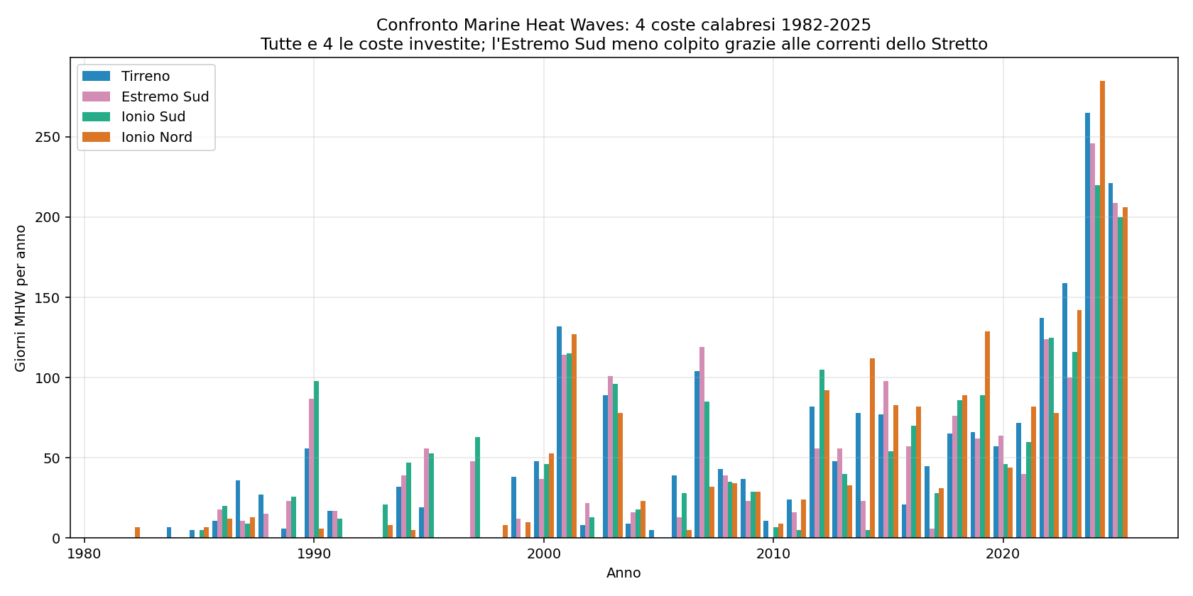
Figure 3 — Marine Heat Wave days per year and per coast, 1982-2025. All four coasts show the same explosion of frequency over the last 5 years; the North Ionian is the one most affected in 2024.
Results for 2024 (a record year):
| Coast | MHW days 2024 |
|---|---|
| Tyrrhenian | 265 |
| Far South | 246 |
| South Ionian | 220 |
| North Ionian | 285 |
Here too the most surprising figure is that the North Ionian (285 days) exceeds the Tyrrhenian (265 days): three quarters of 2024 were in an MHW state for the Crotone area and the Sibari plain. The idea that the Ionian is 'more protected' from heatwaves has no foundation.
The South Ionian (Locri, Soverato, Catanzaro Marina) is indeed less affected (220 MHW days), but still well beyond the stress threshold for sensitive ecosystems.
The Far South (Strait, Reggio, Capo dell'Armi, Capo Spartivento, Bovalino) records 246 MHW days, in an intermediate position: fewer than the Tyrrhenian but more than the South Ionian. The presence of the Strait of Messina with its lively currents offers significant thermal protection, but not total.
4. Wind: the key difference between the Tyrrhenian and the Ionian
If temperature is not enough to explain the differences, this is where the second factor in mucilage formation comes into play: wind. A prolonged calm sea = thermal stratification that does not break down = conditions favourable to mucilage; a windy sea = vertical mixing = mucilage hindered.
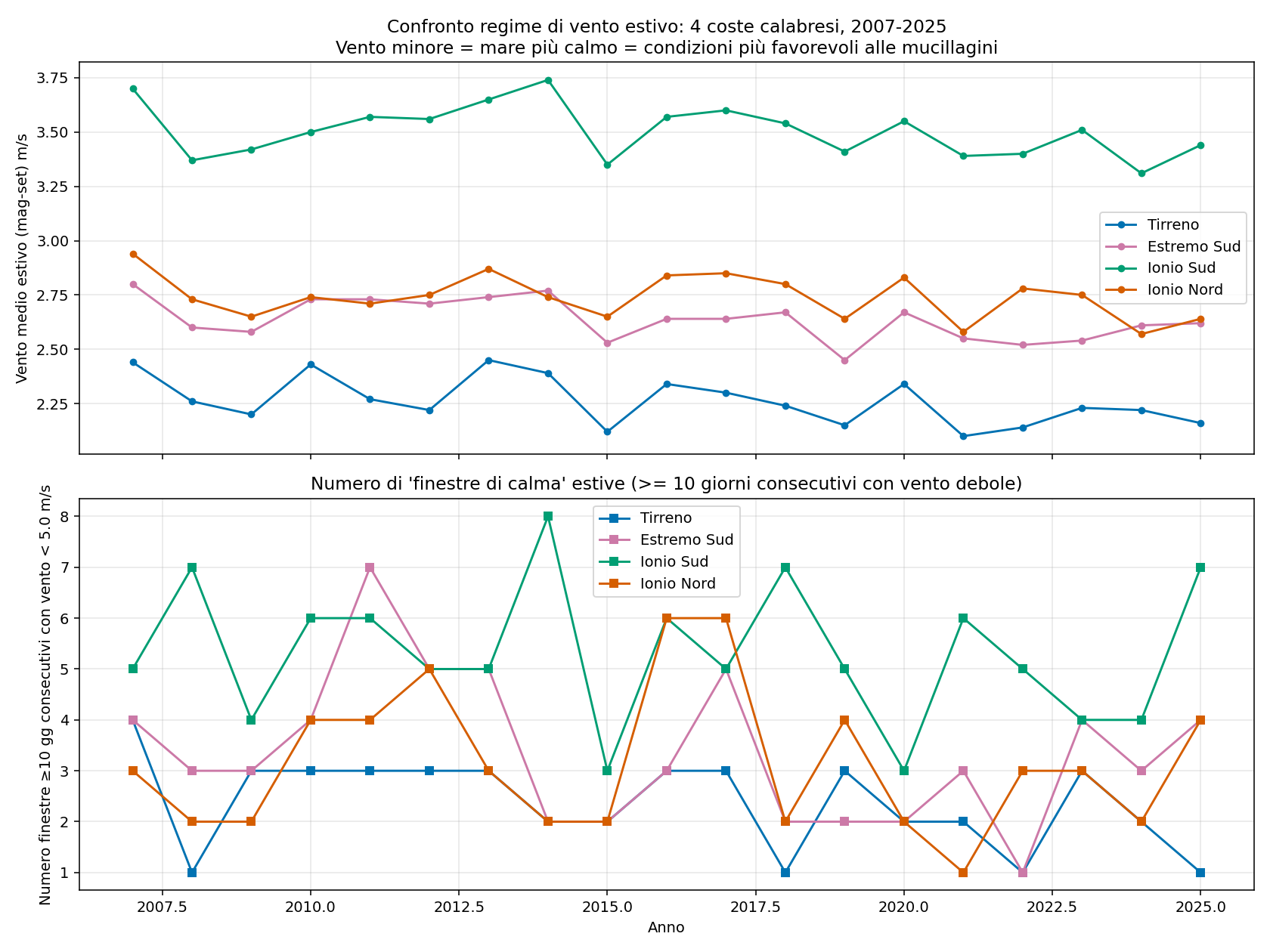
Figure 4 — Summer wind regime (May-Sep) for the four coasts, 2007-2025. Upper panel: annual mean summer wind. Lower panel: number of 'calm windows' (≥10 consecutive days with wind <5 m/s) per year. The South Ionian is structurally windier than the Tyrrhenian, but it also has more calm spells (a bipolar regime). The Far South is in an intermediate position because of the channelling of the Strait of Messina.
What changes between the four coasts
| Indicator | Tyrrhenian | Far South | South Ionian | North Ionian |
|---|---|---|---|---|
| Mean summer wind (May-Sep), 2007-2025 average (m/s) | 2.26 (calmest) | 2.64 | 3.50 (+55%) | 2.74 |
| Calm windows >=10 days / year (2007-2025 average) | 2.4 | 3.4 | 5.3 (most frequent) | 3.2 |
| Mean wind summer 2024 (m/s) | 2.22 | 2.61 | 3.31 | 2.57 |
| Calm windows 2024 (number) | 2 | 3 | 4 | 2 |
The South Ionian is the windiest of all (mean summer wind of 3.50 m/s against the 2.26 m/s of the Tyrrhenian: +55%). This is consistent with the atmospheric regime typical of the Calabrian Ionian coast, exposed to the Grecale-Levante winds that cross the Strait of Otranto and to the Sirocco winds that blow along the south-north axis of the Ionian Sea.
However, the figure on the 'calm windows' is less obvious: the South Ionian, although windier on average, has more prolonged calm spells (5.3 per year against the 2.4 of the Tyrrhenian). This means that the regime there is more 'bipolar' (it alternates strong winds with prolonged calms), whereas the Tyrrhenian has a constant weak wind. For mucilage purposes, however, prolonged calm windows are more important than the mean wind: a 15-day calm phase with SST >25 °C is exactly the perfect setup.
The Far South (Strait-Reggio area-Bovalino) has an intermediate wind regime (2.64 m/s mean, 3.4 calm windows per year): less calm than the Tyrrhenian (probably because of the strong channelling effect of the Strait of Messina), but less windy than the open South Ionian. The currents of the Strait are in any case a very effective mixing factor, independent of the surface wind.
The North Ionian, by contrast, has an intermediate regime: wind slightly stronger than the Tyrrhenian (2.74 vs 2.26 m/s) and intermediate calm windows. This is compatible with lower exposure to the dominant winds, partly screened by the promontory of Capo Colonna and by the Sila massif.
4.1 Visual check: the Global Wind Atlas map
To give a geographical sense of the wind regime over Calabria, Figure 5 shows the GWA climatology at 10 m, with a resolution of 250 m. The wind corridors (channelling between reliefs), the zones sheltered by the promontories, and the sharp Tyrrhenian/Ionian contrast are visible.
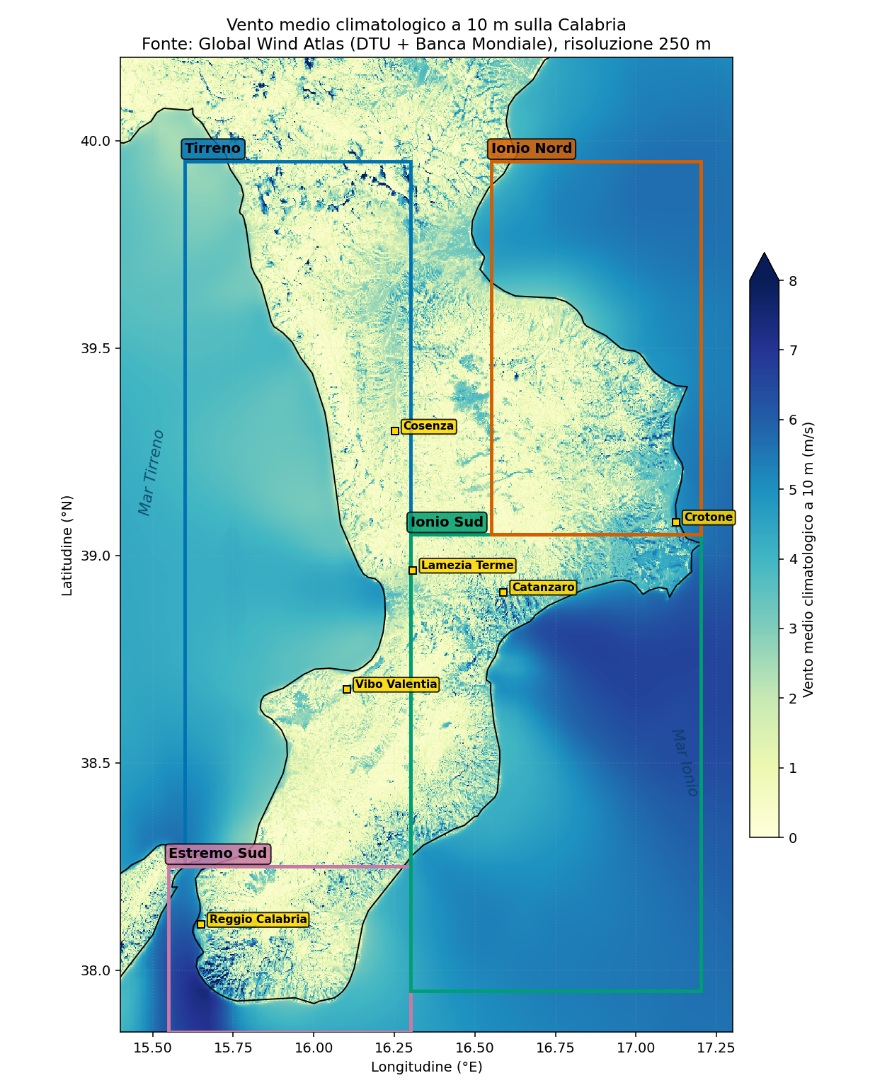
Figure 5 — Climatological mean wind at 10 m over Calabria, source Global Wind Atlas (DTU + World Bank), 250 m resolution. The four boxes indicate the analysed areas. Note the lighter colour (weak wind) over the Calabrian Tyrrhenian coast and in the Gulf of Sant'Eufemia, and the darker colour (stronger wind) over the South Ionian, especially offshore.
Reading the map
- The Tyrrhenian, in particular the Gulf of Sant'Eufemia, shows light colours (2-3 m/s): confirmation of a weak and sheltered regime.
- The South Ionian off Locri-Soverato shows darker shades (4-5 m/s offshore): unhindered Grecale-Levante wind.
- The North Ionian (Crotone area, Sibari plain) has intermediate shades, similar to the Tyrrhenian but with greater variability towards the open sea.
- Note how the mountainous interior (Pollino, Sila, Aspromonte) has markedly higher values, due to the mountain peaks: the GWA in these zones is less meaningful for coastal conditions but useful as an orographic reference.
5. Multifactor index: thermal + mechanical
By combining the two measurable factors (thermal and mechanical), a composite index of mucilage precursor preconditions was built for each of the four coasts, normalised 0-100 and available for the period of overlap of the two datasets (2007-2025).
Composition of the index (weights 50% thermal + 50% mechanical):
- 20% mean May SST (percentile rank over the whole series)
- 15% earliness of the first day with SST ≥22 °C (the earlier, the worse)
- 15% number of days in the critical 24-28 °C window
- 25% number of summer calm windows ≥10 days
- 25% mean summer wind (the lower, the worse)
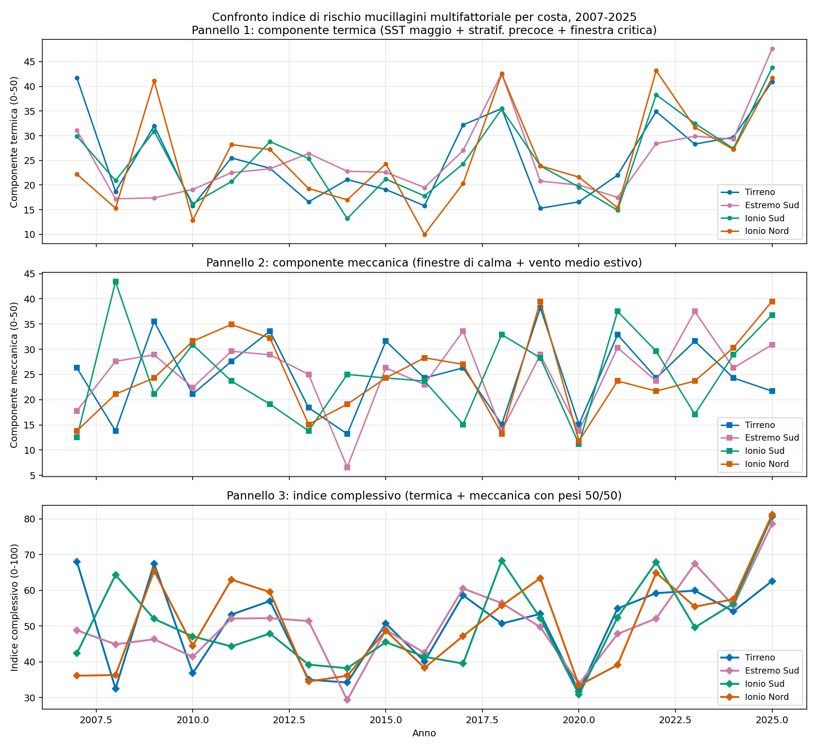
Figure 6 — Multifactor index of mucilage precursor preconditions for the four Calabrian coasts, 2007-2025. Panel 1: thermal component only. Panel 2: mechanical component only (wind). Panel 3: overall index (thermal + mechanical with 50/50 weights).
What the index reveals
- The thermal component is practically indistinguishable between the four coasts. It confirms that, from the heat point of view alone, the Ionian is as exposed as the Tyrrhenian (and the Far South only marginally less).
- The mechanical component clearly differentiates the South Ionian (low values: high wind = less favourable) from the Tyrrhenian (high values: low wind = more favourable), with the North Ionian and the Far South in intermediate positions.
- In the overall index, the Tyrrhenian emerges as the coast with the thermal + mechanical conditions most favourable to mucilage formation, and the South Ionian as the least favourable. The North Ionian is in an intermediate position but closer to the Tyrrhenian.
An important caveat: this index measures only the meteo-marine precursors. It does not include nutrients (river inputs, discharges), bathymetry, currents or the morphology of the coast - all factors that are crucial for explaining why an event actually occurs or not. See Chapter 6.
6. The causes of the differences: beyond temperature and wind
The comparison of SST and wind partly explains the differences but leaves a large margin open, especially for the North Ionian (as warm as the Tyrrhenian, with wind only slightly higher, yet less frequent mucilage). This chapter discusses the most solid hypotheses found in the literature for the causes that are neither thermal nor mechanical.
6.1 Bathymetry: the quantitative check
Perhaps the most relevant factor - and we can now demonstrate it with data. The bathymetry of the Mediterranean was downloaded from the Copernicus Marine product 'MEDSEA_MULTIYEAR_PHY_006_004' (the static variable deptho, resolution ~4.2 km), and specific indicators were computed for each box.
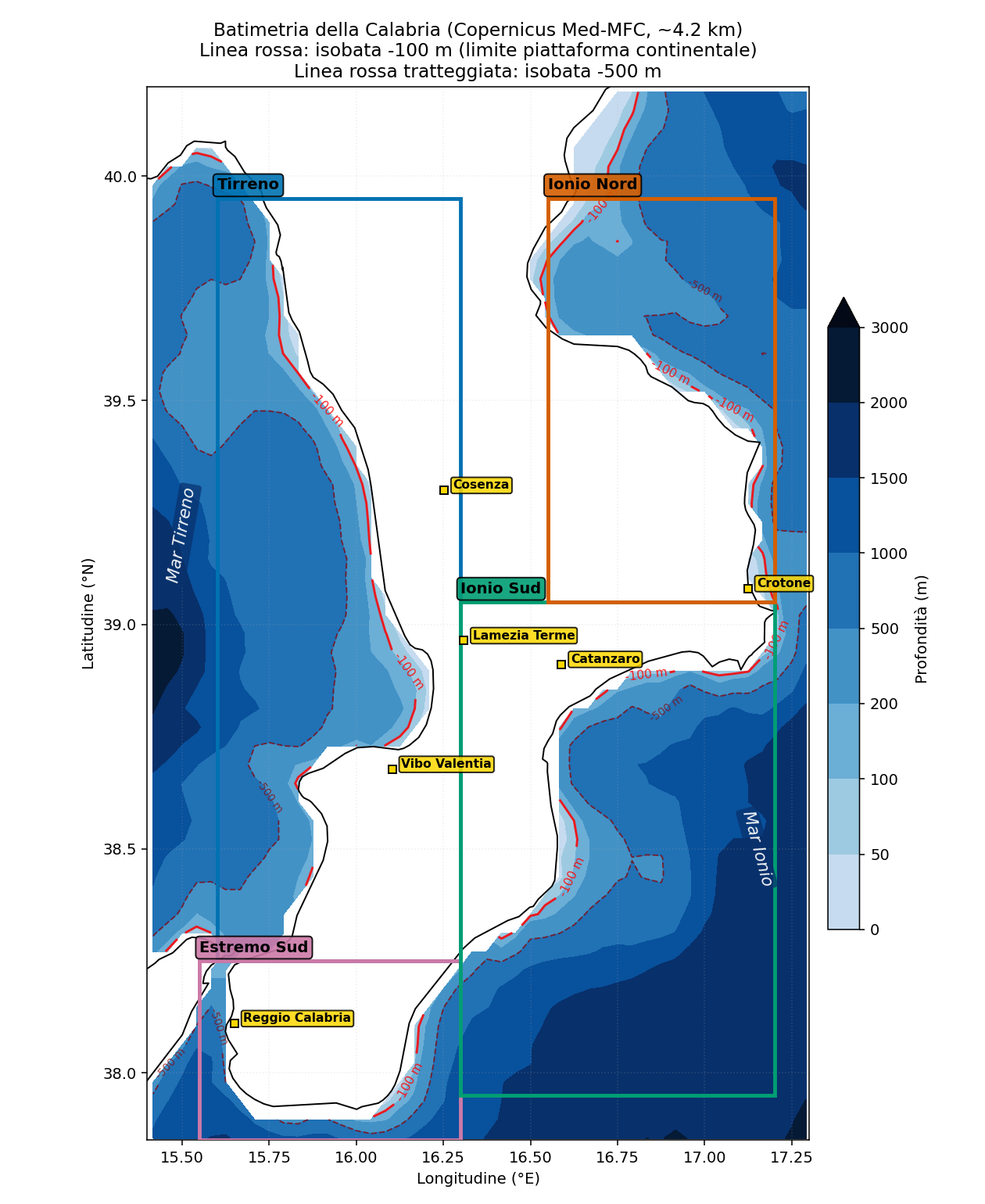
Figure 7 — Bathymetry of Calabria with the 4 analysis boxes. Colours from light blue (shallow waters) to dark blue (>3000 m). The solid red line is the -100 m isobath (the conventional limit of the continental shelf); the dashed red line is the -500 m isobath. The contrast between the Tyrrhenian (an extended shelf, especially in the Gulf of Sant'Eufemia) and the South Ionian (a rapid drop within less than 5 km of the coast) can be seen at a glance.
The figures partly refute (and partly confirm) the qualitative hypothesis
| Bathymetric indicator | Tyrrhenian | Far South | South Ionian | North Ionian |
|---|---|---|---|---|
| Mean depth of the box (m) | 493.8 | 697.7 | 1093.6 | 441.3 |
| Median depth (m) | 491.8 | 666.4 | 1189.5 | 412.7 |
| Maximum depth (m) | 1,185 | 1,530 | 1,823 | 1,017 |
| % of area with depth <= 50 m | 3.4% | 3.7% | 1.8% | 6.1% |
| % of area with depth <= 100 m (shelf) | 9.2% | 6.1% | 5.4% | 14.1% |
| % of area with depth <= 200 m (margin) | 19.8% | 19.5% | 8.4% | 23.3% |
| % of area with depth <= 500 m | 50.9% | 39.0% | 19.6% | 59.5% |
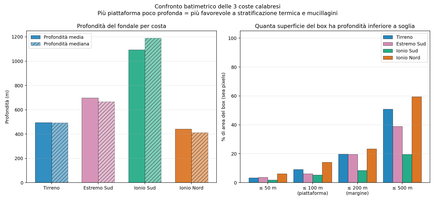
Figure 8 — Bathymetric comparison between the four coasts. Left: mean and median depth per box. Right: percentage of the area of each box with depth less than 50, 100, 200, 500 m. The Tyrrhenian and the North Ionian have comparable structures (wide shelves); the South Ionian is structurally much deeper; the Far South is in an intermediate position.
The four coasts have very different bathymetric structures
The most surprising result of this analysis is that Calabrian bathymetry is not uniform: four coasts, four different profiles:
- The South Ionian (Locri-Soverato-Catanzaro Marina) has a mean depth of 1,094 m: more than double the Tyrrhenian (494 m). Only 19.6% of the area has a depth <=500 m, against 50.9% of the Tyrrhenian. It is structurally the most 'open sea' of the four coasts, with a rapid drop of the seabed and dynamic mixing facilitated.
- The Far South (Strait-Reggio area-Bovalino) has a mean depth of 698 m, intermediate between the Tyrrhenian and the South Ionian. The continental shelf <100 m is reduced (6.1%), lower than the Tyrrhenian (9.2%) and the North Ionian (14.1%). The strong currents of the Strait of Messina add a powerful dynamic effect, independent of depth.
- The North Ionian (Crotone-Cirò-Sibari plain), by contrast, is structurally similar to the Tyrrhenian: a mean depth of 441 m (in fact slightly less than the Tyrrhenian), 14.1% of area with a shelf <=100 m (against the 9.2% of the Tyrrhenian). It is favoured by the promontory of Capo Colonna and by the alluvial plain of Sibari. It is therefore normal that it shows MHW values and thermal anomalies similar to or even higher than the Tyrrhenian.
- The Tyrrhenian has the peculiarity of the Gulf of Sant'Eufemia (about 25 km wide, with shallow seabeds) which creates an area of particularly stable stratification.
So the hypothesis 'bathymetry explains the differences' must be reformulated: it clearly explains why the South Ionian is less affected (a rapid drop = mixing) and is consistent with the coolness of the Far South (the currents of the Strait + a significant bathymetric drop). But it does NOT explain why the North Ionian seems to suffer less than the Tyrrhenian in mucilage reports - indeed, from a structural point of view it is similar or more favourable to the formation of the same. There, social factors probably come into play (less concentrated tourism, fewer reports) or specific nutrients/currents.
6.2 Dominant currents
The Tyrrhenian and the Ionian have different circulation regimes:
- Southern Tyrrhenian: anticyclonic circulation with semi-stationary eddies, especially in the gulfs (Sant'Eufemia, Squillace). Low mean speed, slow water renewal.
- Northern Ionian: the Atlantic Ionian Stream (AIS) enters from the Sicily Channel and runs along the northern edge. Higher mean speeds, faster renewal.
- Central and southern Ionian: dominated by the Mid-Ionian Jet and by the circulation associated with the Pelops Anticyclone (Greece). More lively dynamics than the Calabrian Tyrrhenian.
More renewal = less time for the phytoplankton cells to enter prolonged stress and accumulate exopolysaccharides. This is a possible explanation complementary to bathymetry.
6.3 Coastal configuration
The very shape of the coast influences the preconditions for mucilage:
- Semi-enclosed gulfs (e.g. the Gulf of Sant'Eufemia, the Gulf of Squillace): they favour the stagnation of surface waters. Even with a moderate external wind, inside the gulf calm conditions are more frequent and prolonged.
- A straight coast or promontories (much of the south-central Ionian): a poor capacity to retain still water, the open-sea wind reaches the coast without obstacles.
- Capes and small bays (Capo Spartivento, Capo dell'Armi, Punta Stilo): they create zones of turbulent disturbance useful for mixing.
The Calabrian Tyrrhenian coast has 2 large semi-enclosed gulfs (Sant'Eufemia, Squillace) - a configuration that amplifies these preconditions relative to the more open coast of the Ionian.
6.4 River inputs and nutrients
Mucilage also needs nutrients (nitrogen, phosphorus) in the pre-summer phase. The balance of river input between the Calabrian Tyrrhenian and Ionian is interesting:
| Coast | Characteristics of the river inputs |
|---|---|
| Calabrian Tyrrhenian | Short rivers, with a torrential regime (Lao, Savuto, Angitola, Mesima). Inputs concentrated in the spring floods, then a drastic reduction in summer. Moderate total volume. Distributed human load (the coastal treatment plants of Belvedere, Cetraro, Paola, Lamezia, Falerna). |
| Far South | Few rivers relevant for discharge; urban streams that cross Reggio Calabria predominate (Annunziata, Calopinace, Sant'Agata). Modest water inputs as a mass but with a concentrated human load (~180,000 inhabitants). |
| South Ionian | Small rivers (Stilaro, Petrace, Allaro). Limited inputs. Modest human load, small coastal municipalities. |
| North Ionian | Important rivers: the Crati (158 km, the second-longest of Calabria), the Neto (84 km), the Tacina, the Trionto. Substantial inputs especially in spring; significant autumn floods. The presence of the Sibari plain with intensive agriculture (nitrogen from fertilisers). |
From this reading, the North Ionian would paradoxically have the highest nutrient load of the four coasts (the Crati + the Neto + the agriculture of the Sibari plain). Yet it is not the zone most reported for mucilage. This means that - in the absence of the other two conditions (prolonged calm + stable stratification) - even an abundance of nutrients does not lead to the event.
An indirect confirmation of the concept already recalled in the main report: mucilage requires the temporal coincidence of three factors, not the presence of just one. The Tyrrhenian too, which has more favourable mechanical conditions, has a concentrated nutrient load (Sant'Eufemia/Lamezia, a densely populated area). It is the combination that makes the event.
6.5 Summary of the hypotheses and updated ranking after the bathymetric data
In the light of the quantitative analysis of the bathymetric data, the ranking of the factors that explain the differences between coasts is as follows:
| Importance | Factor | Summary |
|---|---|---|
| 1st - solid | Bathymetry (South Ionian vs the others) | The South Ionian has a mean depth of 1,094 m (more than double the Tyrrhenian) and less than half the continental shelf. It robustly explains why Locri-Soverato-Catanzaro Marina is structurally less favourable to persistent stratification and therefore to mucilage. |
| 1st - solid | Currents of the Strait (Far South) | The Far South is the coast with the lowest summer SST (26.41 °C, vs the 27.31 of the Tyrrhenian). The mixing effect of the currents of the Strait of Messina, combined with an intermediate bathymetry (697 m), produces a measurable dynamic cooling. |
| 2nd - solid | Wind regime (Tyrrhenian vs South Ionian) | The Tyrrhenian has a constant weak wind (2.26 m/s in summer), the South Ionian is 55% windier (3.50 m/s). Independently confirmed by the Global Wind Atlas. It explains the Locri-Soverato vs Tyrrhenian difference jointly with bathymetry. |
| 3rd - hypothetical | Coastal configuration | The Tyrrhenian has 2 large semi-enclosed gulfs (Sant'Eufemia, Squillace); the Ionian has a more open coast with promontories (Capo Colonna, Capo Spartivento). It influences local stagnation but has not been directly quantified. |
| 4th - puzzling | North Ionian vs Tyrrhenian | The North Ionian has a bathymetry (441 m mean) and SST (26.91 °C in 2024) similar to or even more 'favourable' than the Tyrrhenian (494 m, 27.31 °C), yet mucilage reports seem fewer. Possible explanations: more dynamic currents (the Atlantic Ionian Stream), fewer reports due to lower tourism pressure, local specifics of the nutrients (Crati/Neto inputs). To be investigated with specific ARPA observations. |
| 5th | Sea temperature in absolute value | The difference between the four coasts is < 0.9 °C in absolute value. It does not discriminate significantly between zones, but it is the driver of the overall trend: everywhere the situation worsens as the years go by. |
| 6th | Nutrient inputs | The North Ionian has the largest inputs (the Crati, the Neto, the Sibari plain) but is not the coast most affected: a confirmation that without the coincidence of calm + stratification, an abundance of nutrients alone is not enough. |
7. Conclusions and operational implications
7.1 What the comparison tells us
- The four Calabrian coasts (Tyrrhenian, Far South, South Ionian, North Ionian) are subject to marine warming of practically identical intensity in terms of trend. The average difference is < 0.9 °C - modest.
- All four coasts have seen an explosion of Marine Heat Waves over the last 5 years; the North Ionian even has more MHW days than the Tyrrhenian in 2024 (285 vs 265).
- The Far South (Strait-Reggio area-Bovalino) is the coolest coast in summer SST (26.41 °C in 2024) and has 246 MHW days, intermediate. The strong currents of the Strait of Messina, combined with the intermediate bathymetry (697 m), ensure a significant dynamic cooling, although not sufficient to avoid the MHW.
- Wind is genuinely different: the South Ionian is +55% relative to the Tyrrhenian; this partly explains (but not entirely) the lower frequency of mucilage events on the Locri-Soverato coast.
- Bathymetry is decisive in explaining the case of the South Ionian: a mean depth of 1,094 m (more than double the Tyrrhenian), only 19.6% of the area has a shelf <=500 m (vs 50.9% of the Tyrrhenian). The rapid drop of the seabed favours dynamic mixing.
- A surprise: the North Ionian is structurally similar to the Tyrrhenian in bathymetry, SST anomaly and MHW. The fact that mucilage reports are fewer is therefore not explained by the physical parameters - it remains to be understood whether the perceived difference reflects real conditions (currents, salinity, nutrients) or just lower reporting (fewer tourism operators, less social media).
7.2 Implications for communication and land management
Three messages emerge strongly from the data:
- The Ionian is not 'safe'. The narrative that the Ionian is immune to the phenomenon is wrong: the thermal conditions are identical to the Tyrrhenian, and the phenomenon could occur (less frequently, but still occur) if the mechanical conditions changed even only slightly. In 2024 the Crotone area had 285 days of MHW.
- The differences between coasts are structural, not simple. Explaining the differences requires talking about the shape of the coast, bathymetry and currents, not just temperature. Simplistic reductions ("the Tyrrhenian is warm, the Ionian is cold") are misleading.
- Operational monitoring must be differentiated. For the Tyrrhenian, the precursor index based on SST + calm windows has direct operational sense. For the Ionian - where the wind regime is windier and more dynamic - complementary indicators (e.g. current anomalies, surface salinity) should be introduced to better capture the cases of conditions favourable to mucilage.
7.3 Limitations of the analysis
- The Copernicus wind covers only 19 years (2007-2025), against the 44 of the SST. The long-term trends of wind alone are less robust.
- Nutrient data (chlorophyll, nitrogen, phosphorus) were not analysed directly. This analysis would require the Copernicus biogeochemical (BGC) products and is outside the current scope, but it would be the most sensible next step to close the circle of the three triggering factors of mucilage (thermal, mechanical, nutritive).
- Bathymetry was analysed statically (mean depth and shelf bands) but not as a dynamic driver (vertical mixing, depth of the thermocline). A rigorous check of these aspects would require the analysis of the vertical profiles of the MEDSEA_MULTIYEAR_PHY circulation model (Med-MFC).
- Currents are treated only qualitatively, based on the literature. Quantifying them would require the surface velocities of the Med-MFC model, which are not difficult to download but must be processed ad hoc.
- The mucilage phenomenon was not directly quantified (systematic temporal observational data for Calabria are lacking). The considerations concern potential exposure, not the actual occurrence of events.
7.4 Possible future developments
- Spatial extension: include the Sicilian coast (Tyrrhenian and Ionian) and the Campania coast to validate the Tyrrhenian-Ionian pattern in other regions.
- Adding the salinity variable: a Copernicus dataset is available, and it can help to discriminate zones of strong river input.
- Integration with direct observations: in collaboration with ARPA Calabria and local operators, the systematic collection of geo-located mucilage reports to validate the precondition map.
- Development of the online monitoring app: for the Tyrrhenian the alert system based on SST + wind has immediate applicability; for the Ionian it will require specific calibration.
— End of the comparison report —